INTRODUCTION
The purpose of this article is to draw attention to and spark interest in a special parcel of land on the North Tract. For the purposes of this article, I will call it the “Inner Core.”

There some rare and uncommon plant communities in this area. One plant community of particular interest is the Southern Red Maple – Black Gum Swamp Forest, a type of acidic seepage swamp. It is found in several places on the North Tract, but none are in as pristine condition as the one in the Inner Core. This plant community is considered globally rare (G3) because of its limited distribution. The future preservation of this community on the refuge will be determined by the level of protection and the type of management provided. There are other plant communities found in the Inner Core, which while not rare, are uncommon and deserve elevated protection. Even if none of the plant communities in the Inner Core were rare or uncommon, the fact that such a biologically pristine area exists at all within a large metropolitan area is significant and would in my opinion still deserves a high level of protection.
BOGGY AREA ON THE SOUTHERN EDGE OF BEAVER VALLEY
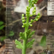
Numerous boggy areas are found within this area, but they are too small to be listed as vegetation types. One good area for this type of micro-community is the southern edge of Beaver Valley. They are usually typified by mats of sphagnum moss growing on top of a gravelly base. Boggy areas usually contain plant species that are not found in other locations. Fringe orchids (Platanthera ssp.) are examples of species found in these areas.
The possibility of finding rare and unusual plant species in the Inner Core is high. One rare plant to be on the lookout for in the Inner Core and adjacent areas is the federally threatened (G2) is Swamp Pink (Helonias bullata). Further study within this area and adjacent areas may yield some interesting finds.
LOCATION
The Inner Core is located in the area east of the Wood Duck Pond and includes the land that surround what is known as Beaver Valley and Shangri La. This area is known for its palustrine wetlands which formed from ancient riverbeds of the Little Patuxent River. The precise boundary of the Inner Core is fuzzy because it impossible to determine where the area ends and non-Inner Core land begins. What can be done is to exclude certain surrounding areas, and guess on the rest.

Area outlined in red = Inner Core
NOTE: the alignments are approximate.
HISTORICAL BACKGROUND
Let’s look at the history of this area to see why it is so pristine.
There is clear evidence of human settlement activity in the area surrounding the Inner Core. Maps from 1860 and the later 1800’s show that at least three homesteads existed in the western part of the Inner Core. There may have been abortive attempts at farming, but the swampy nature and inaccessibility may have made farming difficult. However, initial observations show that the trees in the Inner Core are mostly second growth, clearly indicating a history of logging. More study of the area is needed to understand the extent and impact of historic settlement and logging.
Historical maps show some primitive roads in the area, including one that runs just south of Beaver Valley and another one that transverses the Inner Core from northwest to southeast. However, it may be impossible to determine the exact alignment of these two roads by ground truthing because of their original primitive condition and because vegetation has overgrown the roadbeds.
If there was ever any settlement activity in the Inner Core, it would have come to an end in 1917 when the Army acquired the land for a military installation. Most of the land acquired by the Army at the time was north of the Little Patuxent River, with a small parcel of land south of the Little Patuxent River. The Inner Core is part of this small “south of the river” parcel. According to a US Geological Survey map from 1918, the “south of the-river” parcel is roughly bounded by the Little Patuxent River on the north and east, Telegraph Road to just north of Wood Duck Pond on the west, then by a line that runs roughly southeast from a point just north of Wood Duck Pond to a point near Salamander Pond, and finally by a line which runs northeast from that point towards the Little Patuxent River. Because of map resolution issues, the border of the “south of the river” parcel is not precisely determined.
Between 1917 and the late 1930’s, the Army probably did not conduct large scale exercises in the “south of the river” parcel because there was enough land available north of the river to conduct exercises, and the area was remote being on the “other side of the river.” For a short time in the 1930’s, the Inner Core was part of the “Meade National Forest” when the Army temporarily gave up control of a major part of the military installation. In the late 1930’s, the winds of war brought a great change, when the army re-acquired the “Meade National Forest” and annexed a large portion of land south of the Little Patuxent and north of the Patuxent River.
Since the late 1930’s, the Inner Core was probably largely ignored because military exercises could now be conducted in the large parcel of newly acquired land which was more accessible. Inner Core was also part of an area on Fort Meade which was used as an artillery shell impact zone. As a result, unexploded ordnance in the Inner Core and other areas probably became a concern for the area’s use for exercises.
Sometime before 1990, the Army stopped using the area as an impact zone, but the danger of unexploded ordnance lingered. After the early 1990’s when control of a large portion of Fort Meade was transferred to the Fish and Wildlife Service, the only significant human activity in the Inner Core has been hunting and biological surveying.
COMMENTS ABOUT INVASIVE SPECIES
When one visits the Inner Core, you are struck by the absence of invasive plants when compared to the rest of the North Tract. That said, initial observations of the area indicate that there are some invasive species in the area, such as Japanese honeysuckle (Lonicera japonica), Japanese barberry (Berberis thunbergii), and common reedgrass (Phragmites australis). A small number of populations of the first two species with few individual plants are found in the mesic woods which surround the palustrine wetlands. The common reedgrass (Phragmites australis) has been found in a couple of small isolated populations. Further study will probably show isolated pockets of other invasive species, but if they exist, they are probably not as pervasive as elsewhere on the North Tract
BOTTOMLAND FLOODPLAIN EXCLUDED
Although the bottomland floodplain along the Little Patuxent River also has had minimal human influence over the years, it is excluded from the Inner Core. This is because invasive plants have negatively altered the original pristine condition of the bottomlands. Various invasive species, such as lesser celandine (Ranunculus ficaria), ivy-leaved speedwell (Veronica hederifolia), Japanese knotweed (Fallopia japonica), Japanese stilt grass (Microstegium vimineum), and creeping Charlie (Glechoma hederacea), have been introduced into the bottomlands from outside of the refuge by periodic flooding and have taken a strong foothold. The Inner Core wetlands are subject to occasional flooding, but their relative higher elevation means that they are out of the Little Patuxent River floodplain which would slow the spread of these invasive species.
CONCLUSION
The Inner Core can provide a rich area for future biological research. Perhaps elevated protection of some kind may be warranted to minimize future human impact on this area. The comparative lack of human activity and the relative pristine condition of the Inner Core make it a special place on the North Tract, indeed a biological time capsule. I hope this article has sparked some interest.
ANNEX
NVC VEGETATION ASSOCIATIONS IDENTIFIED IN THE INNER CORE AND ADJACENT AREAS
Related Posts
Pine Needle Gall Midge –
Thecodiplosis cf. brachynteroides on Virginia Pine –
5 July 2019
Matt Beziat and I spotted some Pine Needle Gall Midge…
One Reply to “The Inner Core – Untouched by Human Hands (Mostly)”